She also works on developing techniques aimed at using Earth observation images more effectively, whether they are satellite images or taken from planes. Her work involves an important element of applied mathematics, modeling and optimization.
The researcher defines her input as being an intermediary between image acquisition from space agency sensors (such as the Centre National d’Etudes Spatiales – CNES or the European Space Agency – ESA) and the specialists who will be dealing with applications in various contexts (characterizing and monitoring an urban environment, monitoring natural environments, etc.).
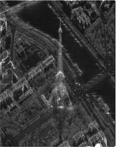
Florence Tupin’s work focuses mainly on Synthetic Aperture Radar imaging (SAR). This is an imaging radar which uses the antenna’s aperture to improve resolution, thanks to appropriate signal processing methods. The data obtained by this type of sensor is very rich: it is complex data, the phase of which is linked to the geometry of the scene and it can have a variety of polarizations, indicating the physical properties of objects. However, they show a great degree of granularity and many fluctuations. The researcher contributed to defining the NL-SAR (Non-Local Synthetic Aperture Radar) method, which is highly effective in reducing these fluctuations and relies on the search for redundant local information. This very general method is used in different types of applications to improve signals.
The article presenting this method, « NL-SAR: A Unified Nonlocal Framework for Resolution-preserving (Pol)(In)SAR Denoising”, which she co-signed with Charles-Alban Deledalle, Loïc Denis, Andreas Reigber and Marc Jäger, was recognized with the “IEEE Transactions on Geoscience and Remote Sensing Prize Paper Award” in 2016, by rewarding an exceptional publication in terms of content and impact in the IEEE TGRS Journal every year.
These research projects have very practical applications, as they are currently being adapted to processing the data that is to be acquired by the future ESA BIOMASS mission planned for 2020. The aim of this mission is to measure the biomass of forests, especially those located in tropical areas for which radar capture, capable of penetrating through cloud cover, is particularly useful. A method like NL-SAR reduces variability in the measurements extracted from images.
A partnership between CNES and NASA resulted in another project, the future SWOT sensor, which is dedicated to developing algorithms that are able to automatically extract water and river surfaces from Earth observation images, in order to subsequently calculate their height. As with several of the projects undertaken, the objective is to make the best use of the acquisition system and to model assumptions, so as to improve processing performance.
Current and future work is directed towards the processing and analysis of multitemporal series taken in a wide sense (mono- or multi-sensors), given that, thanks especially to ESA’s Sentinel-1 and 2 missions, long series of Earth images are now available, paving the way for new applications and calling for new processing techniques.