Best paper: Carla Geara awarded in IEEE Geoscience and Remote Sensing Letters
04 May 2026
This research is conducted by Carla Geara, a PhD student under an industrial-academic partnership with the company Kanop, and supervised by Florence Tupin at Télécom Paris in collaboration with ONERA.
The work builds on previous research by the IMAGES team at LTCI, which has been developing deep learning methods to enhance satellite radar images for several years. These images, acquired by emitting electromagnetic waves in the microwave frequency range, are subject to strong fluctuations (a phenomenon known as « speckle noise »).
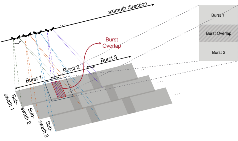
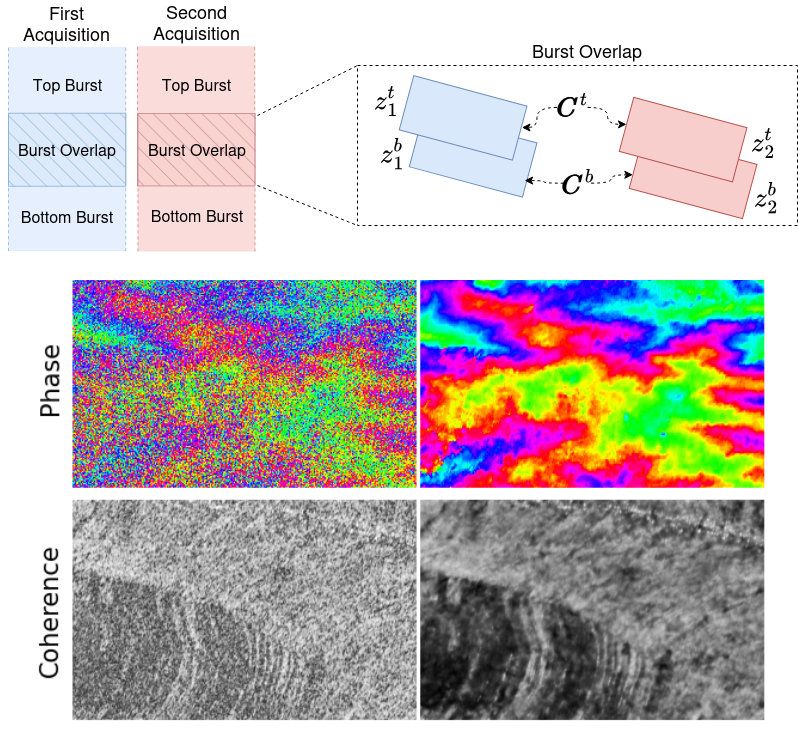
In this paper, we focus on interferometric data, which allows height information to be derived from two radar images by exploiting phase differences. The proposed approach extends and adapts the SAR2SAR [2] and POLSAR2POLSAR [3] methods, which processed amplitude (wave magnitude) and polarimetric data. It leverages the specific acquisition geometry of Sentinel-1 images in IW (Interferometric Wide) TOPSAR mode, which provides radar images with overlapping areas viewed from different angles. This results in two acquisitions with independent speckle noise, enabling the training of a neural network in a self-supervised manner without ground truth images.
This research was carried out as part of Carla Geara’s PhD thesis, which explores the potential of radar data for forest monitoring applications developed by the start-up Kanop.
The Geoscience and Remote Sensing Society (GRSS) is a technical Society of the Institute of Electrical and Electronics Engineers (IEEE). GRSS fosters engagement of its members for the benefit of society through science, engineering, applications, and education as related to the development of the field of geoscience and remote sensing.
[1] C. Geara, C. Gelas, L. d. Vitry, E. Colin and F. Tupin, « Extending InSAR2InSAR to Sentinel-1 Data » in IEEE Geoscience and Remote Sensing Letters, vol. 22, pp. 1-5, 2025, Art no. 4008105
[2] SAR2SAR: a semi-supervised despeckling algorithm for SAR imagesEmanuele Dalsasso, Loïc Denis, Florence Tupin, IEEE Journal of Selected Topics in Applied Earth Observations and Remote Sensing, In press, pp.1-1. ⟨10.1109/JSTARS.2021.3071864⟩
[3] POLSAR2POLSAR: A SEMI-SUPERVISED DESPECKLING ALGORITHM FOR POLARIMETRIC SAR IMAGES Cristiano Ulondu Mendes, Emanuele Dalsasso, Yi Zhang, Loïc Denis, Florence Tupin ISPRS Journal of Photogrammetry and Remote Sensing, 2025, 220 (0924-2716), pp.783-798